Monday 28 October 2019

The course of a river

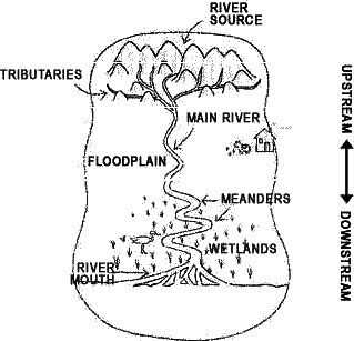
  • Explain the difference between the upper course, middle course and lower course of a river.
  •  Where is the place to erosión? , and to the deposition of sediments?
  • What types of reliefs are possible in these areas? Look  for information here and in your book, page 42
 
Complete the table:
 

Course of a river
Parts Where? Main features
Upper


Middle


Lower


Link to investigate

Rivers

Link to: How Rivers and Streams Affect the Earth's Surface

Vocabulary Unit 3. Water

Unit


  • Water Cycle
  • Fresh water
  • Groundwater
  • Flow
  • Basin
  • Tributary
  • Source
  • Glacier
  • Lake
  • River
  • Canal
  • Reservoir
  • Dam
  • Hidroelectric power station
  • Salinity
  • Warm current
  • Cold current
  • Tide
  • Wave
  • High tide
  • Low tide
  • Lagoon
  • Inland sea
  • Ocean current
  • Aquifer
  • Spring
  • Drinking water
  • Iceberg
  • Drought
  • Flood
  • Water Pollution
  • Acid rain
  • Homework:
    • You have to look for the meaning of these words and write them in english;
    You need to know these words and your meanings for the next exam. I´m going to ask you.

    Sunday 27 October 2019

    Tuesday 22 October 2019

    Gradation Process

    Weathering

    TASK:
    • Explain how relief is modified. What are the main external agents?
    • Do you think more than one external agent can modify relief at the same time? How? Explain the diferent ways

    Why is Mount Everest so tall?

    Monday 21 October 2019

    Earthquakes


    Agents of gradation Wind

    Vocabulary Unit 2

    • Alluvial plain: It is a flat, fertile area where the river deposits sediment.
    • Archipelago: It is a group of islands.
    • Basin: It is natural depression, or low areas of land. Some are below sea level.
    • Bay: It is a small gulf.
    • Beach: It is a flat coastal area.
    • Canyon: It is a deep channel with steep walls.
    • Cape: It is a part of the coast which extends into the sea.
    • Cliff: They are steep rock formations in high coastal areas.
    • Continental Drift: It is a new theory. There was only continent, which broke up millions of years ago. (Pangaea).
    • Continental shelf: It is a place near coastlines. These shelves are vast plateaus which reach of 150 metres.
    • Continental slope: It is a place to lead down to the deeper part of oceans.
    • Core: It is the deepest layer of the Earth. The core is part solid and part liquid.
    • Crater: It is the upper of volcano when magma comes out.
    • Crust: It is the surface layer of the Earth. It is a thin, solid layer made of rock.
    • Delta: It is a triangular area at the mouth of a river.
    • Earthquake:It is caused by plate tectonics. When two plates crash, there is a release of energy that makes the ground vibrate. This vibration is an earthquake.
    • Erosion: It is the fragmentation and dissolution of rocks, soil and mud, which is transported by wind or water.
    • Estuary: It is the part of a river where it meets the sea.
    • Fault: They are blocks rise or sink.
    • Fluvial erosion: the rivers erode materials, and create deep valleys and canyons.
    • Fold: They are created when the Earth’s surface undulates where plates collide.
    • Gulf: It is a large area of a sea or ocean partially enclosed by land.
    • Island: It is an area of land surrounded by water on all sides.
    • Isthmus: It connects a peninsula to a continent.
    • Lava: It is magma comes out of a volcano.
    • Lower course: It is down part the river.
    • Lower mantle: It is the intermediate layer. It has a depth of 700 to 3,000 km.
    • Magma: It is molten rock. It is a very hot material that comes out when a volcano is an opening.
    • Mantle: It is the intermediate layer of the Earth. This layer is almost 85% of the Earth’s volume.
    • Marine Erosion: waves and currents wear away coasts and create cliffs. The water transports the sediment and deposits it. It forms beaches.
    • Middle course:It is a middle part the river.
    • Mountain: They are high landforms with steep sides.
    • Mountain range: It is a group of mountains.
    • Ocean Ridge: It is a large mountain range in the ocean floor .
    • Ocean Trench: They are large, deep depressions in the ocean floor.
    • Peninsula: It is an area of land surrounded by water on all sides except one.
    • Pipe: It is a part of volcano through the magma rises.
    • Plain: They are low, flat areas of land.
    • Plateau: They are large, raised plains.
    • Sediment: They are the erosion’s materials which rests on a basin.
    • Solution: water dissolves some rocks, such as limestone, producing unusual caves and landscapes.
    • Tectonic Plate: They are the different plates the Earth’s crust. It is a theory
    • Tsunami: It is an earthquake on the ocean floor.
    • Upper course: It is  the high part in  a river.
    • Upper mantle: this is a  layer of the Earth that  has a depth of 70 to 700 km. It is below the crust.
    • Valley:It is an area of low land between mountains.
    • Volcano:It is an opening in the surface of the Earth through which very hot material comes out.
    • Waterfall: It is a section of a river where the water falls vertically.

    Sunday 20 October 2019

    How Noth America go its shape

    Continents, countries, and even mountain ranges didn't always look the way they look now. Millions of years ago, every continent had a different shape. The force that changes continents and mountains is called tectonics, and each continent sits on a tectonic plate.

    Read pages 28 and 29 in the textbook, and answer the questions.
    Also think about why tectonic plates, volcanoes, and earthquakes are connected. link

    .
    After watching the video, answer:
    • What happens when one plate goes underneath another?
    • What did the continents look like  millions of years ago? 
    • What does "rift" mean? 
    • Name the different tectonic plates in this region on the video

    Thursday 17 October 2019

    Volcanoes

    .
    Task: Make a summary
    What is a volcano?
    What are the different parts in a volcano?

    Link here to know more
    Explore some volcanoes


    Sunday 13 October 2019

    The 15 most amazing landforms

    Shaped and sculpted over millions of years, these stunning landscapes and rock formations hold invaluable clues to Earth's past and future ( link to the BBC page)


    Tuesday 8 October 2019

    Describing landscapes


    Describe  these landscapes using the words that you know.
    After that, send me a e-mail with the writing description.


    Ver DELTA DEL EBRO ACCESIBLE en un mapa más grande

    Monday 7 October 2019

    Basic geographic terms


    Vocabulary Unit 2

    Unit 2
    • Alluvial plain
    • Archipelago
    • Basin
    • Bay
    • Canyon
    • Cape
    • Cliff
    • Continental Drift
    • Continental shelf
    • Continental slope
    • Core
    • Crater
    • Crust
    • Delta
    • Earthquake
    • Erosion
    • Estuary
    • Fault
    • Fluvial erosión
    • Fold
    • Gulf
    • Island
    • Istmus
    • Lava
    • Lower course
    • Lower mantle
    • Magma
    • Mantle
    • Marine Erosion
    • Middle course
    • Mountain
    • Mountain range
    • Ocean Ridge
    • Ocean Trench
    • Peninsula
    • Pipe
    • Plain
    • Plateau
    • Sediment
    • Solution
    • Tectonic Plate
    • Tsunamic
    • Upper course
    • Upper mantle
    • Valley
    • Volcano
    • Waterfall
    Homework:

    • You have to look for the meaning of these words and write in english about them;
    • You need to know these words and your meanings for the next exam. I´m going to ask you.