.
TASK:
Make the summary about the global atmospheric circulatión. Send me by e-mail
Tuesday, 17 December 2019
What is global atmospheric circulation?
What is global atmospheric circulation?

Global atmospheric circulation model
The movement of air between the equator and 30° north and south is known as the Hadley Cell. Air rises again at around 60° north and south and descends again around 90° north and south forming the Ferrel and Polar Cell.
Global atmospheric circulation creates winds across the planet as air moves from areas of high pressure to areas of low pressure. It also leads to areas of high rainfall, like the tropical rainforests, and areas of dry air, like deserts
Friday, 13 December 2019
Depressions and Anticyclones
Depressions are areas of low pressure,in other words
the air is rising. They bring clouds and rain to the United Kingdom.
They originate over the Atlantic and then travel with the prevailing
winds in a North East direction across the country.
Depressions occur when two air masses meet, one is a warm, moist mass from the tropics, whilst the other is a cool, dense mass from the Pole.
The two air masses meet at a front, and the warm air is forced to rise over the cold air. This is called the warm front. At the same time the cold air circles around behind the warm air and undercuts, lifting the warm air off the ground. This is called the cold front. The two air masses spiral around each other and slowly move across the country.

As a depression moves overhead you can recognise 5 stages in order:
Winds are very light in an anticyclone, as the air moves outwards from the centre in a clockwise motion (in the Northern Hemisphere).
Anticyclones can occur throughout the year and cause different effects when they happen in the winter rather than the summer.
Summer Effects:
a) Describe the type of weather associated with anticyclones.
b) Describe the type of weather associated with depressions.
c) Explain why these types of weather occurs.
d) What is pressure measured in?
e) What type of pressure would you expect to find during an anticyclone.
Answer
Depressions occur when two air masses meet, one is a warm, moist mass from the tropics, whilst the other is a cool, dense mass from the Pole.
The two air masses meet at a front, and the warm air is forced to rise over the cold air. This is called the warm front. At the same time the cold air circles around behind the warm air and undercuts, lifting the warm air off the ground. This is called the cold front. The two air masses spiral around each other and slowly move across the country.

As a depression moves overhead you can recognise 5 stages in order:
- Initially as the depression approaches you will get a build up of high cirrus and stratus clouds. This is because the warm air that has been forced to rise has begun to condensate.
- The cloud will continue to accumulate overhead as the warm front approaches. The clouds will be lower nimbostratus ones and there will be steady rainfall. The temperature will also fall.
- Once the warm front has passed, you are in the section between the two fronts where the warm air still is touching the ground. This causes the temperature to increase, often from approximately 6 to 12C. There may be some light drizzle, but mostly it is dry during this warm sector.
- The next part is the arrival of the cold front. You would be able to see this clearly coming towards you as it is a steep front with huge high cumulonimbus clouds, bringing with them very heavy rain. The temperatures also fall asthe cold front moves overhead.
- Finally, once the cold front has passed, you get a mixture of sunshine and heavy showers, caused by pockets of rising air in the air that follows the depression.
- The whole process takes between 12 and 24 hours.


Winds are very light in an anticyclone, as the air moves outwards from the centre in a clockwise motion (in the Northern Hemisphere).
Anticyclones can occur throughout the year and cause different effects when they happen in the winter rather than the summer.
Summer Effects:
- Anticyclones bring hot and sunny weather due to there being clear skies (because of the descending air). The days are long and the sun high in the sky, which gives ample opportunity for the land to be heated up. These conditions could lead to convectional rainfall occurring.
- Anticyclones bring clear days in the winter as well. However the sun is low in the sky and the days are short, meaning you get cool, crisp days.
- Clear skies on a winter's night will allow frost to form. The land quickly loses heat during the night, as there is no cloud cover to act as insulation. The rapidly cooling ground cools and condenses any moisture in the air above it, forming droplets of ice when the temperature falls below freezing. This is frost.
- Fogs are also caused by clear winter nights. The ground loses heat. This cools the air above it causing moisture to condensate around dust particles in the layer of air closest to the ground surface. This is fog.
- The descending air creates dry conditions, as air will warm as it descends, meaning that it can actually hold more water, and so will not need to drop it.( link to this material)
a) Describe the type of weather associated with anticyclones.
b) Describe the type of weather associated with depressions.
c) Explain why these types of weather occurs.
d) What is pressure measured in?
e) What type of pressure would you expect to find during an anticyclone.
Answer
Tuesday, 3 December 2019
Environmental Problems´ Presentation

These presentations will make in groups of 2 people. You send me your work. Some groups show us your presentation in class.
Monday, 2 December 2019
Types of rainfall
There are three common types of rainfall, all of which occur in Spain. All have the common theme of air being forced to rise.
As air rises it cools it cannot hold as much moisture as it could when it was warmer. Eventually the rising air reaches a point where it is 100% saturated, in other words it cannot hold any more water. This is called dew point, and it is above this point that condensation occurs.
Condensation is the process by which the water vapour (a gas) held in the air is turned back into water droplets (a liquid), which fall as rain.
Very common in areas where the ground is heated by the hot sun, such as the Tropics. This is why those areas experience heavy rainfalls most afternoons. The United Kingdom does experience some convectional rainfall during the summer, particularly in the South East of the country.
Convectional rainfall occurs when:
- The surface of the earth is heated by the sun.
- The warm surface heats the air above it. Hot air always rises so this newly heated air does so.
- As it rises the air-cools and begins to condensate.
- Further rising and cooling causes a large amount of condensation to occur and rain is formed.

The United Kingdom experiences a lot of frontal rainfall, as it is associated with the movement of depressions over the country, which are described in more detail elsewhere in this topic.
Frontal rainfall occurs when:
- Two air masses meet, one a warm air mass and one a cold air mass.
- The lighter, less dense, warm air is forced to rise over the denser, cold air.
- This causes the warm air to cool and begin to condense.
- As the warm air is forced to rise further condensation occurs and rain is formed.
- Frontal rain produces a variety of clouds, which bring moderate to heavy rainfall.

This is also called orographic rainfall, which is very common in the United Kingdom, especially on the West coast since the prevailing weather comes from that direction.
Relief Rainfall occurs when:
- The prevailing winds pick up moisture from the sea as they travel across it, making the air moist.
- The moist air reaches the coast and is forced to rise over mountains and hills.
- This forces the air to cool and condense, forming clouds.
- The air continues to be forced over the mountains and so it drops its moisture as relief rain.
- Once over the top of the mountain the air will usually drop down
the other side, warming as it does so. This means it has a greater
ability to carry water moisture and so there is little rain on the far
side of the mountain. This area is called the rain shadow. ( link to this material)

Sunday, 1 December 2019
Friday, 29 November 2019
Tuesday, 26 November 2019
Vocabulary Unit 4. Weather and climate

Unit 4
|
|
Homework:
Monday, 25 November 2019
Friday, 22 November 2019
Vocabulary Unit 3
- Water Cycle : It is the process when the water changes its physical state.
- Fresh water : It is the water found in rivers, lakes, glaciers, groundwater and at the poles.
- Groundwater : It is the water run and is scored under the ground.
- Flow : It is the amount of water it carries
- Basin : It is the area occupied by a river and its tributaries.
- Tributaries : It is smaller rivers flowing into a large river.
- Source : It is the place of a river starts.
- Glaciers : They are masses of ice created by the accumulation of snow.
- Lakes : They are permanent masses of water which have accumulated inland.
- Wadis : They are basins in the desert.
- Rivers : They are permanent currents of water
- Canals : It is build by human beings, and used to transport water.
- Reservoirs : They are artificial lakes to store water.
- Water supply : It is the water in reservoirs and is offered to people and industries.
- Dams : They are build of human beings used to produce electricity.
- Hydroelectric power station : It is a station used to produced electricity through the water.
- Salinity : It is the amount of salt with containing the oceans and seas.
- Warm current : These currents are produced when the temperature of a current is higher than the water around it.
- Cold current : These currents are produced when the temperature of a current is colder than the water around it.
- Tides : They are the diary rise and fall of the water level. They are caused by the gravitational forces of the Moon and the Sun.
- Waves : They are undulations of the surface of the water produced by wind.
- High tide : This tide is produced when rise the level of sea.
- Low tide : This tide is produced when falls the level of sea.
- Lagoons : It is smaller lakes.
- Inland seas : It is a saltwater lake.
- Ocean currents : They are large masses of water, similar to rivers, which circulate through oceans.
- Aquifers : It is forms when the water can´t pass through the impermeable rocks
- Springs : It is forms when groundwater finds a way to the surface. They can be cold or hold water.
- Drinking water : It is the water you can drink. Groundwater is valuable because there are drinking water.
- Icebergs : It is a floating mass of ice.
- Consumption : It is the fresh water which use the human being for life. It is only 0.014%.
- Droughts : It is shortage of water.
- Floods : It is excess of water
- Water Pollution : It is large amount of materials are added to a body of water.
- Acid rain: It contains harmful chemicals such as sulfur and nitrogen. These chemicals are released into the atmosphere as gases.
Thursday, 21 November 2019
Friday, 15 November 2019
Monday, 11 November 2019
Saturday, 9 November 2019
Thursday, 7 November 2019
Tuesday, 5 November 2019
Investigating about the ocean

You have to do these activities:
- Why is the ocean salty
- What causes Waves?
- What causes Tides?
- What is a Tsunami?
- What
are Deepest depth?
Monday, 4 November 2019
Sunday, 3 November 2019

Saturday, 2 November 2019
Monday, 28 October 2019
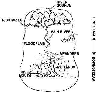
The course of a river
- Explain the difference between the upper course, middle course and lower course of a river.
- Where is the place to erosión? , and to the deposition of sediments?
- What types of reliefs are possible in these areas? Look for information here and in your book, page 42

Complete the table:
| Course of a river | ||
| Parts | Where? | Main features |
| Upper | ||
| Middle | ||
| Lower | ||
Vocabulary Unit 3. Water
Unit
Water Cycle
Fresh water
Groundwater
Flow
Basin
Tributary
Source
Glacier
Lake
River
Canal
Reservoir
Dam
Hidroelectric power station
Salinity
Warm current
Cold current
Tide
Wave
High tide
Low tide
Lagoon
Inland sea
Ocean current
Aquifer
Spring
Drinking water
Iceberg
Drought
Flood
Water Pollution
Acid rain
Homework:
- You have to look for the meaning of these words and write them in english;
Sunday, 27 October 2019
Saturday, 26 October 2019
Friday, 25 October 2019
Tuesday, 22 October 2019
Weathering
TASK:
- Explain how relief is modified. What are the main external agents?
- Do you think more than one external agent can modify relief at the same time? How? Explain the diferent ways
Monday, 21 October 2019
Vocabulary Unit 2
-
Alluvial plain: It is a flat, fertile area where the river deposits sediment.
-
Archipelago: It is a group of islands.
-
Basin: It is natural depression, or low areas of land. Some are below sea level.
-
Bay: It is a small gulf.
-
Beach: It is a flat coastal area.
-
Canyon: It is a deep channel with steep walls.
-
Cape: It is a part of the coast which extends into the sea.
-
Cliff: They are steep rock formations in high coastal areas.
-
Continental Drift: It is a new theory. There was only continent, which broke up millions of years ago. (Pangaea).
-
Continental shelf: It is a place near coastlines. These shelves are vast plateaus which reach of 150 metres.
-
Continental slope: It is a place to lead down to the deeper part of oceans.
-
Core: It is the deepest layer of the Earth. The core is part solid and part liquid.
-
Crater: It is the upper of volcano when magma comes out.
-
Crust: It is the surface layer of the Earth. It is a thin, solid layer made of rock.
-
Delta: It is a triangular area at the mouth of a river.
-
Earthquake:It is caused by plate tectonics. When two plates crash, there is a release of energy that makes the ground vibrate. This vibration is an earthquake.
-
Erosion: It is the fragmentation and dissolution of rocks, soil and mud, which is transported by wind or water.
-
Estuary: It is the part of a river where it meets the sea.
-
Fault: They are blocks rise or sink.
-
Fluvial erosion: the rivers erode materials, and create deep valleys and canyons.
-
Fold: They are created when the Earth’s surface undulates where plates collide.
-
Gulf: It is a large area of a sea or ocean partially enclosed by land.
-
Island: It is an area of land surrounded by water on all sides.
-
Isthmus: It connects a peninsula to a continent.
-
Lava: It is magma comes out of a volcano.
-
Lower course: It is down part the river.
-
Lower mantle: It is the intermediate layer. It has a depth of 700 to 3,000 km.
-
Magma: It is molten rock. It is a very hot material that comes out when a volcano is an opening.
-
Mantle: It is the intermediate layer of the Earth. This layer is almost 85% of the Earth’s volume.
-
Marine Erosion: waves and currents wear away coasts and create cliffs. The water transports the sediment and deposits it. It forms beaches.
-
Middle course:It is a middle part the river.
-
Mountain: They are high landforms with steep sides.
-
Mountain range: It is a group of mountains.
-
Ocean Ridge: It is a large mountain range in the ocean floor .
-
Ocean Trench: They are large, deep depressions in the ocean floor.
-
Peninsula: It is an area of land surrounded by water on all sides except one.
-
Pipe: It is a part of volcano through the magma rises.
-
Plain: They are low, flat areas of land.
-
Plateau: They are large, raised plains.
-
Sediment: They are the erosion’s materials which rests on a basin.
-
Solution: water dissolves some rocks, such as limestone, producing unusual caves and landscapes.
-
Tectonic Plate: They are the different plates the Earth’s crust. It is a theory
-
Tsunami: It is an earthquake on the ocean floor.
-
Upper course: It is the high part in a river.
-
Upper mantle: this is a layer of the Earth that has a depth of 70 to 700 km. It is below the crust.
-
Valley:It is an area of low land between mountains.
-
Volcano:It is an opening in the surface of the Earth through which very hot material comes out.
-
Waterfall: It is a section of a river where the water falls vertically.
Subscribe to:
Posts (Atom)